Principal Investigator(s): Ben A. Leshchinsk
Associate Investigator(s): Michael J. Olsen
Senior Person(s): Jaehoon Jung
Project Starting Year: 2019
Project Ending Year: 2020
Description(Abstract):
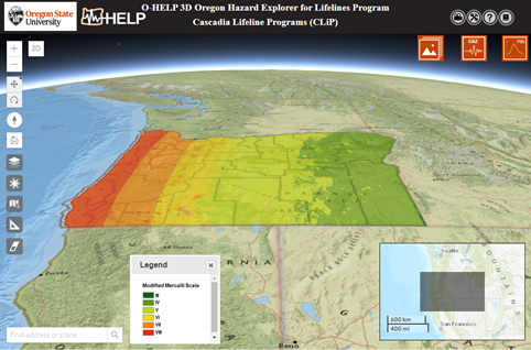
Communities faced with natural hazards, such as earthquakes, immensely benefit from geospatial analyses of data layers representing contributing factors as well as predictions of resulting impacts to infrastructure. The Cascadia Lifelines Program (CLiP) was established to conduct research that will enable informed decisions to mitigate damage to Pacific Northwest infrastructure from Cascadia Subduction Zone (CSZ) earthquakes. CLiP has sponsored the development of a freely available web-GIS platform, the Oregon Hazards Explorer for Lifelines Program (O-HELP, http://ohelp.oregonstate.edu), which currently serves as an integrated data portal used to present technical information regarding various CSZ-related hazards, including landslides, liquefaction, lateral spreading, fault rupture subsidence, and tsunami inundation. It is also a source of other relevant engineering data in a geospatial context, including anticipated ground motions, peak ground accelerations, soil conditions (boreholes), bridges and roads, geology maps, and an inventory of past landslides. Recently, the O-HELP interface is being expanded to support 3D data, which will help communicate hazards better as well as provide context that can be lost in a flattened, 2D representation. O-HELP 2.0 is envisioned to be a central hub to integrate important engineering products to provide resources to enable communities in Oregon to be more resilient.